
All posts in City
38 Posts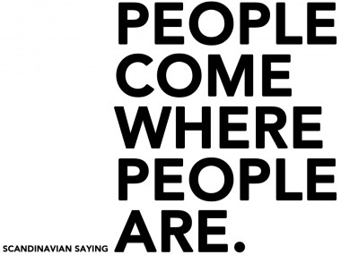
New shared places.
The study of public spaces is configured as a transformation; operations that happen through the usage and actions on pre-existing conditions. This occurs through spontaneous actions and sometimes temporary ones.
For example, In the events that took place after the occupation of Zuccoth Park in New York in September 2011 it was seen that the camps were forming “a common space rather than a single political cause”, “the appropriation of space itself, or in the jargon of the occupants, the liberation of space “.1
“The city is an eminently collective fact that is defined and is in those works
whose nature is essentially collective; and even borning though such works as means to build the city, they soon become a goal; and we do this in their being and their beauty. ” A. Rossi, L’architettura della città.
Possibilities that arise from the opportunity of being in the same space like seeing or hearing other peoples, can be evaluated observing people’s reaction to the presence of other people as observed by Jan Gehl.
It is generally true that people and human activities attract other people; An old Scandinavian saying tells it all: “people come where people are.”
The social life in public spaces contributes fundamentally to the quality of life of individuals and society. We have a moral responsibility to create physical places that facilitate civic engagement and community interaction.
William Whyte suggests a new bottom-up, instead of top-down, approach to the designing of public spaces. Using his approach, design should start with a thorough understanding of the way people use spaces and the way they would like to use them. Whyte noted that people vote with their feet – they use spaces that are easy to use, that are comfortable. They don’t use the spaces that are not. Through observations and by chatting with people, we can learn a great deal about what people want in public spaces and we can put this knowledge to work creating places that shape liveable communities. We should therefore enter spaces without theoretical or aesthetical biases, and “look hard, with a clean, clear mind, and then look again – and believe what you see.” 4
When outdoor areas are qualitatively poor only strictly necessary activities occur. On the contrary, when outdoors areas are of high quality, necessary activities take place with approximately the same frequency, but they tend to last longer becoming social activities.
“Social activities are all activities that depend on a the presence of others in public spaces. The character of social activities varies, depending on the context in which they occur.”2
Social activities transform the environment on which they are practiced.
The concept of transformation assumes a fundamental role in the usage of space and architecture. Transformation means to act on the environment, modifying the surrounding shapes that characterize it.
Beside the open spaces, architecture organizes also the surrounding spaces. The shape varies in its use in a way that adapts to the circumstances.
Siegfried Giedion wrote about the Renaissance city as the possibility of “re-use of forms” 3. He claims that the new formulation of urban elements characterizes certain historical periods of the city and it does not go through their invention instead. On the contrary, an innovative composition produces a redefinition of the elements and changes with the use of places, without changing their spatial conception.
Is important to give innovative and bright ideas concerning public spaces design in contemporary cities, especially for the spaces without a recognized role in the society. The marginal areas that are elect as new spaces by the users.
Identifying the marginal areas, that become a new part of the social life and have the opportunity to be part of the society and have the opportunity to suggest new scenarios and design of open spaces and architecture: real shared places.

REFERENCES
- Benecit Cluette e Marlisa Wise – Note da un’occupazione, Domus, Gennaio 2012.
- Jan Gehl – Life between buildings, using public space, Van Nosrand Reinhold Company, New York. 1986.
- S. Giedion, Space, time and architecture (1941), tr. it. Spazio, tempo, architettura, Hoepli, Milano 1984
- The Essential William H. Whyte, Albert Lafarge (Editor), Fordham University Press, 2000.
Petržalka case study.
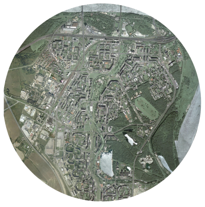
Bratislava is the cultural and economical capital of Slovakia. The city is crossed by the river Danube, one of the most important European rivers. The end of World War I in November 1918 brought major changes to the map of Europe. The Austro- Hungarian Empire dissolved and the Czechoslovak Republic was created on October 1918 The Slovak part of Czechoslovakia industrialized rapidly in the 1950s and 1960s, villagers migrated in droves to the cities. The cheapest and quickest way to accommodate them was to construct tower- ing blocks of flats, clumped together densely so that essential services could be delivered to them as efficiently as possible. Large residential areas consisting of high-rise prefabricated panel buildings, such as those in the Petržalka borough, were built. At the territory of today’s Petržalka, city district of the Bratislava, there was located a ford of international importance already in Middle Ages. The beginning of settlements in this territory dates back to 13th cen- tury. According to the oldest description of settlement of today’s Petržalka, there was established village Flezyndorf. In 1866 there lived 594 inhabitants in 103 houses in Petržalka. Fires caused great damage which consequences significantly affected all district inhabitants. Petržalka was indefinitely connected to Bratislava through the first railway bridge, constructed in 1891. In 1946 Petržalka became the part of Great Bratislava. Since 1973 when the decision of liquidating old Petržalka was made, current appearance of this hous- ing estate has been formed. From 1950 and 1965 the number of inhabitants increased from 190.000 to 271.000. An intense production of apartments and residential buildings for all the inhabitants increased slowly in the left side of the city. The requirements of the project were defined in a way to predict a raise of the population up to 350.00 inhabitants. The district of Petržalka is linked to the city centre by five bridges: two for the highway, one old pedestrian bridge and two bridges for Danube car-crossing. The analysis of infrastructures stems from the hierar- chy of the streets serving the area, that is the system linking Petržalka to the rest of the city and to the close Austria, especially Vienna. The area of Petržalka is characterized by several building typologies, different for the plan, the array of the buildings, the height. In all the different parts com- posing Petržalka the buildings have an introvert array, and face the courtyards where the schools lie. Petržalka is full of services like schools, post of- fices and municipalities. Conversely, all other kind of services should have placed in the area according to the original project, but they have never been realized due to the lack of financial resources. The most relevant problem of this area is the highway, which stands as a barrier separating Petržalka from the park and stadium area. The analysis on the area proved the need of creating a mix of services in the central part, in a well planned system which could link the different parts of the district, nowadays completely patchy and scattered.
For the development of the strategy I focused on the infrastructural aspect, by identifying the most impor- tant infrastructural axes and defining their function and influence on the surrounding territory.
The central part, which during the creation of Petržalka was designed to host services and func- tions missing in the district (and then never built due to the lack of financial resources), currently displays some poles at both the city scale (e.g. the Stadium) and (mostly) the district scale. The missing axis, which has a great landscape potential thanks to the channel and to the big green central space, today is left abandoned. In my intervention strategy I propose to revaluate this potential and re-establish the original function of this axis, by adding the new functions and missing public spaces, concurrently increasing the value of the surrounding landscape. In order to give value to the urban green in the area I consider the hypothesis of reconverting all the green space standing in the central part into a multi purpose green axis, where landscape, buildings and infrastructures interact naturally in order to provide higher breadth to the district and to tackle its massive constructions. With specific reference to the open space, our strategy has the mission to differentiate it into squares, green areas with facilities, green for sport, naturalistic greenery, picnic areas, boulevards, in order to create a mix of possible uses. Mobility plays a fundamental role, with the introduc- tion of a fast tram line serving as the structural axis for the intervention. The buildings that are about to be built represent a filling of the current public space rather than a presence facing the surrounding con- text. My intent is also to tackle the area identity issue, as the inhabitants have difficulties to distinguish the different part of the area, or to find their own house. Our strategy points at differentiating the area into three parts, characterized by the presence of the fol- lowing functional themes: In order to identify a reference grid for the articulation of the public space, I observed how over time a lot of spontaneous pedestrians routes randomly cross- ing the channel area came to life, beyond the spaces carefully and strictly designed in the socialist era. These routes, mostly never ending and traced in the existing green, define a patchy track which coasts all the design area. In order to articulate the public space, taking into consideration the visual axes as a mean to link the different parts of the area, I started from these routes with the idea of creating a more free fruition of the public space. This also results from the observation of how the inhabitants of Petržalka spontaneously love to walk along and near the chan- nel to reach their destinations. In order to recreate this usage and habit, I considered a hierarchy of secondary lines which could lay on the previously defined grid of primary visual axes. In this project I consequently tried to grant a walkability which could offer a multiplicity of alternatives, with either naturalistic routes and paths or open spaces nearby and along the channel defined by the track of this grid. This in turn creates a landscape system also integrated with the buildings disposition and with the functions we imagined to place in the area. With this intervention of re-qualification I would like to re-establish the human scale in Petržalka, bring- ing back its origins, when it was a small town and its park was a place of interest and attraction for all the city, where took place fairies and events of European resonance. In addition, the agricultural theme in the area of Petržalka brings many perspectives, both in the re- covery of the identity of the district, with the creation of urban vegetable gardens and in the functional aspect interacting with the near agricultural areas and the creation of a farmer market which could bring back again the attention on the local products. The idea of giving new value to the public space propos- ing different thematic poles along the channel (commercial, cultural, sport, agricultural), comes from the willingness to differentiate the several parts of the area and the public space above all, which nowadays has a big lack of characterization and attractions. The area of Petržalka, like all the other urban con- temporary and precedent experiments, proved how the concept of public space spread in those years failed miserably, showing how it was inadequate and not adapt to the inhabitants’ needs, changing so fastly and needing flexibility. In the original project the idea of public space was referred only to the buildings courtyards, and therefore only playgrounds and little sport fields were designed in order to answer to the basic inhabitants’ needs; no any other public space common to all Petržalka has ever been thought and designed. In the course of the time has become evident how the inhabitants need to live their district beyond the basic functions that it can offer, and how the free time is a valuable resource to be preserved in the design of adequate public spaces, outdoor and indoor. My strategy propose to re-establish an equity between the inhabitants and their public space, and to allow them to use a precious resource which today they are not able to enjoy. The quality arises around the people and can be generated by a scale reduction which could foster a new urban identity.
Nicola Petaccia